
Delthota topographic map
Interactive map
Click on the map to display elevation.
About this map
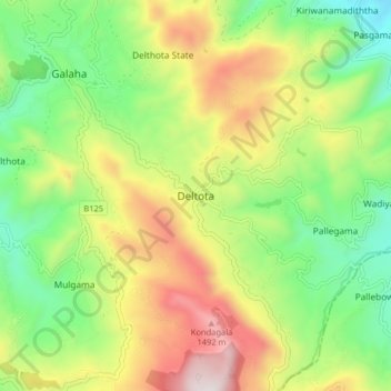
Name: Delthota topographic map, elevation, terrain.
Location: Delthota, Kandy District, Central Province, Sri Lanka (7.13266 80.65600 7.21266 80.73600)
Average elevation: 3,199 ft
Minimum elevation: 1,732 ft
Maximum elevation: 5,338 ft
Other topographic maps
Click on a map to view its topography, its elevation and its terrain.
Wanahapuwa
Sri Lanka > Central Province > Delthota
Wanahapuwa, Delthota, Kandy District, Central Province, 20420, Sri Lanka
Average elevation: 3,140 ft