
Hazard topographic map
Interactive map
Click on the map to display elevation.
About this map
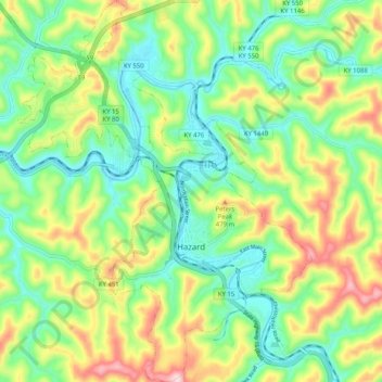
Name: Hazard topographic map, elevation, terrain.
Location: Hazard, Perry County, Kentucky, United States (37.22023 -83.23973 37.30115 -83.16124)
Average elevation: 1,188 ft
Minimum elevation: 830 ft
Maximum elevation: 1,824 ft
Other topographic maps
Click on a map to view its topography, its elevation and its terrain.
Viper
United States > Kentucky > Perry County > Viper
Viper, Perry County, Kentucky, 41774, United States
Average elevation: 1,325 ft
Buckhorn
United States > Kentucky > Perry County
Buckhorn, Perry County, Kentucky, United States
Average elevation: 1,007 ft