
Godmanchester topographic map
Interactive map
Click on the map to display elevation.
About this map
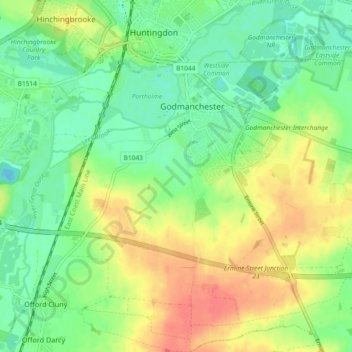
Name: Godmanchester topographic map, elevation, terrain.
Average elevation: 72 ft
Minimum elevation: -10 ft
Maximum elevation: 167 ft
Other topographic maps
Click on a map to view its topography, its elevation and its terrain.
Huntingdon Castle
United Kingdom > England > Cambridgeshire > Huntingdonshire > Godmanchester
Huntingdon Castle, A1307, Newtown, Huntingdon, Godmanchester, Huntingdonshire, Cambridgeshire, Cambridgeshire and Peterborough, England, PE29 3AS, United Kingdom
Average elevation: 46 ft