
Babati topographic map
Interactive map
Click on the map to display elevation.
About this map
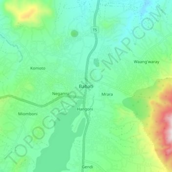
Name: Babati topographic map, elevation, terrain.
Average elevation: 4,567 ft
Minimum elevation: 3,957 ft
Maximum elevation: 6,440 ft
Babati town has developed from a mere village since Babati District was established in 1985. The new status boosted the town into rapid growth. The town is located at an altitude of 2,145 metres or 7,037 feet near the end of Tarangire National Park and the base of Lake Babati, nestling under Mount Kwaraha.
Other topographic maps
Click on a map to view its topography, its elevation and its terrain.
Simanjiro
Simanjiro, Manyara Region, Northern Zone, Tanzania
Average elevation: 3,645 ft
Kwa Kuchinia
Kwa Kuchinia, Babati, Manyara Region, Northern Zone, Tanzania
Average elevation: 3,294 ft