
Thank you for supporting this site ❤️
Make a donation
Make a donation
Gear up for your next adventure:
As an Amazon Associate, this site earns from qualifying purchases at no extra cost to you.
Kiteni topographic map
Click on the map to display elevation.
Thank you for supporting this site ❤️
Make a donation
Make a donation
Gear up for your next adventure:
As an Amazon Associate, this site earns from qualifying purchases at no extra cost to you.
About this map
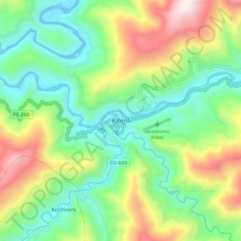
Name: Kiteni topographic map, elevation, terrain.
Location: Kiteni, Echarate, Province of La Convención, Cusco, Peru (-12.68723 -73.08875 -12.60723 -73.00875)
Average elevation: 3,068 ft
Minimum elevation: 1,772 ft
Maximum elevation: 5,535 ft
Thank you for supporting this site ❤️
Make a donation
Make a donation
Gear up for your next adventure:
As an Amazon Associate, this site earns from qualifying purchases at no extra cost to you.