
Boumahra Ahmed topographic map
Interactive map
Click on the map to display elevation.
About this map
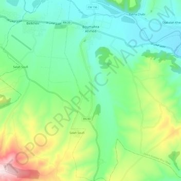
Name: Boumahra Ahmed topographic map, elevation, terrain.
Location: Boumahra Ahmed, Daïra Guelaat Bou Sbaa, Guelma, Algérie (36.37991 7.49715 36.47561 7.61508)
Average elevation: 968 ft
Minimum elevation: 449 ft
Maximum elevation: 2,224 ft
Other topographic maps
Click on a map to view its topography, its elevation and its terrain.
Belkheir
Algérie > Guelma > Daïra Guelaat Bou Sbaa
Belkheir, Daïra Guelaat Bou Sbaa, Guelma, 24100, Algérie
Average elevation: 1,312 ft