
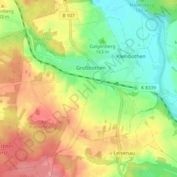
Großbothen topographic map
Interactive map
Click on the map to display elevation.
About this map
Name: Großbothen topographic map, elevation, terrain.
Location: Großbothen, Grimma, Leipzig, Sachsen, Deutschland (51.16270 12.72200 51.20332 12.77832)
Average elevation: 551 ft
Minimum elevation: 417 ft
Maximum elevation: 699 ft
Other topographic maps
Click on a map to view its topography, its elevation and its terrain.
Thümmlitzwalde
Deutschland > Sachsen > Grimma
Thümmlitzwalde, Grimma, Leipzig, Sachsen, Deutschland
Average elevation: 617 ft
Mutzschen
Deutschland > Sachsen > Grimma
Mutzschen, Grimma, Leipzig, Sachsen, Deutschland
Average elevation: 620 ft