
Port hills topographic map
Interactive map
Click on the map to display elevation.
About this map
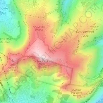
Name: Port hills topographic map, elevation, terrain.
Average elevation: 807 ft
Minimum elevation: 0 ft
Maximum elevation: 1,611 ft
Other topographic maps
Click on a map to view its topography, its elevation and its terrain.
Linwood-Central-Heathcote Community
New Zealand > Canterbury > Christchurch City > Linwood-Central-Heathcote Community
Linwood-Central-Heathcote Community, Christchurch City, Canterbury, New Zealand
Average elevation: 180 ft