Geolocate

Tura topographic map

Click on the map to display elevation.

About this map

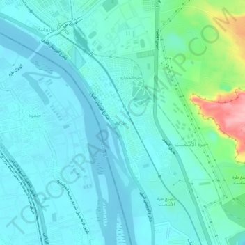
Name: Tura topographic map, elevation, terrain.

Location: Tura, Cairo, 11729, Egypt (29.91459 31.26073 29.95459 31.30073)

Average elevation: 121 ft

Minimum elevation: 43 ft

Maximum elevation: 512 ft

Other topographic maps

Click on a map to view its topography, its elevation and its terrain.

Almaza Park

Egypt > Cairo > Cairo

Average elevation: 246 ft

Fostat garden

Egypt > Cairo > Cairo > EL Sheikh Mubarak

Average elevation: 108 ft

Fustat

Egypt > Cairo > Cairo > EL Sheikh Mubarak

Average elevation: 95 ft

Gear up for your next adventure:

🔦LED Headlamp - Bright and durable LED headlamp for night navigation
🪓Survival Multi‑Tool - Versatile tool for camp and trail tasks
🛡️Insect Repellent - Protection against bugs during outdoor activities
🛠️Backpacking Tool Kit - Essential toolkit for outdoor repairs
🍳Camping Cook Set - Complete cookware for outdoor meals

As an Amazon Associate, this site earns from qualifying purchases at no extra cost to you.