
Make a donation
Gear up for your next adventure:
As an Amazon Associate, this site earns from qualifying purchases at no extra cost to you.
Dawlish topographic map
Click on the map to display elevation.
Make a donation
Gear up for your next adventure:
As an Amazon Associate, this site earns from qualifying purchases at no extra cost to you.
Dawlish
Little of note happened at Dawlish until the end of the 18th century, when seaside locations on the south coast started to become popular with the wealthy, mainly caused by George III making Weymouth in Dorset his summer holiday residence from 1789. In May 1795, the antiquarian and topographer John Swete spent some time in Dawlish and reported that although not long ago it had been no more than a fishing village, and the best lodging house would not cost more than half a guinea per week, it was now so fashionable that "in the height of the season, not a house of the least consequence is to be hired for less than two guineas a week, and many of them rise to so high a sum as four or five."
Make a donation
Gear up for your next adventure:
As an Amazon Associate, this site earns from qualifying purchases at no extra cost to you.
About this map
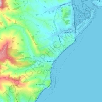
Name: Dawlish topographic map, elevation, terrain.
Location: Dawlish, Teignbridge, Devon, England, United Kingdom (50.55513 -3.52790 50.61777 -3.42288)
Average elevation: 144 ft
Minimum elevation: -3 ft
Maximum elevation: 814 ft
Make a donation
Gear up for your next adventure:
As an Amazon Associate, this site earns from qualifying purchases at no extra cost to you.
Other topographic maps
Click on a map to view its topography, its elevation and its terrain.