
Shahr-e Kord topographic map
Interactive map
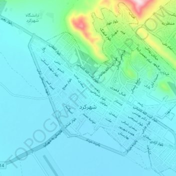
Click on the map to display elevation.
About this map
Name: Shahr-e Kord topographic map, elevation, terrain.
Average elevation: 6,896 ft
Minimum elevation: 6,699 ft
Maximum elevation: 8,176 ft
Shahr-e Kord (Zagros) is located about 90 km (56 mi) southwest of Isfahan and 512 km (318 mi) of Tehran. It is topographically situated in the north of the Zagros Mountains. Being located 2,070 m (6,790 ft) above the sea level, Shahr-e Kord (Zagros) is the most elevated among the centers of the provinces of Iran, known as the Roof of Iran.
Other topographic maps
Click on a map to view its topography, its elevation and its terrain.
دهستان حومه شهرکرد
Iran > Chaharmahal and Bakhtiyari Province > Sharekurd County
دهستان حومه شهرکرد, بخش مرکزی, Sharekurd County, Chaharmahal and Bakhtiyari Province, Iran
Average elevation: 7,313 ft
Farrokhshahr
Iran > Chaharmahal and Bakhtiyari Province > Sharekurd County
Farrokhshahr, بخش فرخ شهر, Sharekurd County, Chaharmahal and Bakhtiyari Province, Iran
Average elevation: 7,067 ft