Geolocate

Cabagan topographic map

Click on the map to display elevation.

About this map

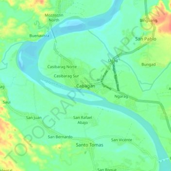
Name: Cabagan topographic map, elevation, terrain.

Location: Cabagan, Isabela, Cagayan Valley, 3328, Philippines (17.38648 121.72491 17.46648 121.80491)

Average elevation: 95 ft

Minimum elevation: 49 ft

Maximum elevation: 210 ft

Other topographic maps

Click on a map to view its topography, its elevation and its terrain.

Magat Dam

Philippines > Isabela

Average elevation: 577 ft

San Guillermo

Philippines > Isabela

Average elevation: 302 ft

Gear up for your next adventure:

☀️Outdoor Sunscreen - High protection sunscreen for outdoor activities
📡GPS Antenna Upgrade - Enhance GPS reception in remote terrain
🧭GPS Watch Accessories - Bands and chargers for GPS watches
🔦Powerful Headlamps - Ultra-bright hands-free lighting for night navigation
🔭Stargazing Telescopes - Perfect for camping in low-light pollution areas shown on maps

As an Amazon Associate, this site earns from qualifying purchases at no extra cost to you.