
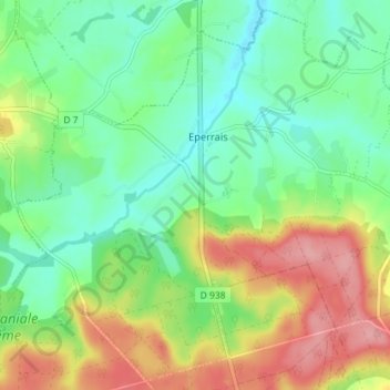
Eperrais topographic map
Interactive map
Click on the map to display elevation.
About this map
Name: Eperrais topographic map, elevation, terrain.
Average elevation: 620 ft
Minimum elevation: 486 ft
Maximum elevation: 837 ft
Other topographic maps
Click on a map to view its topography, its elevation and its terrain.
Les Batailles
France > Normandie > Orne > Belforêt-en-Perche
Les Batailles, Le Gué-de-la-Chaîne, Belforêt-en-Perche, Mortagne-au-Perche, Orne, Normandie, France métropolitaine, 61130, France
Average elevation: 604 ft
Bouvigny
France > Normandie > Orne > Belforêt-en-Perche
Bouvigny, La Perrière, Belforêt-en-Perche, Mortagne-au-Perche, Orne, Normandie, France métropolitaine, 61360, France
Average elevation: 587 ft
Beau Repos
France > Normandie > Orne > Belforêt-en-Perche
Beau Repos, Eperrais, Belforêt-en-Perche, Mortagne-au-Perche, Orne, Normandie, France métropolitaine, 61400, France
Average elevation: 591 ft
Sérigny
France > Normandie > Orne > Belforêt-en-Perche
Sérigny, Belforêt-en-Perche, Mortagne-au-Perche, Orne, Normandie, France métropolitaine, 61130, France
Average elevation: 643 ft
La Petite Grange
France > Normandie > Orne > Belforêt-en-Perche
La Petite Grange, La Perrière, Belforêt-en-Perche, Mortagne-au-Perche, Orne, Normandie, France métropolitaine, 61360, France
Average elevation: 548 ft
Le Champu
France > Normandie > Orne > Belforêt-en-Perche
Le Champu, La Perrière, Belforêt-en-Perche, Mortagne-au-Perche, Orne, Normandie, France métropolitaine, 61360, France
Average elevation: 512 ft
La Perrière
France > Normandie > Orne > Belforêt-en-Perche
La Perrière, Belforêt-en-Perche, Mortagne-au-Perche, Orne, Normandie, France métropolitaine, 61360, France
Average elevation: 571 ft