
Binak topographic map
Click on the map to display elevation.
About this map
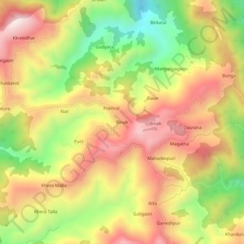
Name: Binak topographic map, elevation, terrain.
Location: Binak, Yamkeshwar, Pauri Garhwal, Uttarakhand, 246121, India (30.01026 78.37615 30.05026 78.41615)
Average elevation: 3,130 ft
Minimum elevation: 1,837 ft
Maximum elevation: 4,255 ft
Other topographic maps
Click on a map to view its topography, its elevation and its terrain.
Elephant Pound Rajaji National park Uttrakhand
India > Uttarakhand > Yamkeshwar
Average elevation: 1,493 ft
Elephant Pound Rajaji National park Uttrakhand
India > Uttarakhand > Yamkeshwar
Average elevation: 1,493 ft
Elephant Pound Rajaji National park Uttrakhand
India > Uttarakhand > Yamkeshwar
Average elevation: 1,493 ft
Elephant Pound Rajaji National park Uttrakhand
India > Uttarakhand > Yamkeshwar
Average elevation: 1,493 ft
Elephant Pound Rajaji National park Uttrakhand
India > Uttarakhand > Yamkeshwar
Average elevation: 1,493 ft