
Thank you for supporting this site ❤️
Make a donation
Make a donation
Gear up for your next adventure:
As an Amazon Associate, this site earns from qualifying purchases at no extra cost to you.
Freixo topographic map
Click on the map to display elevation.
Thank you for supporting this site ❤️
Make a donation
Make a donation
Gear up for your next adventure:
As an Amazon Associate, this site earns from qualifying purchases at no extra cost to you.
About this map
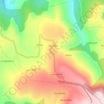
Name: Freixo topographic map, elevation, terrain.
Location: Freixo, Samos, Sarria, Lugo, Galicia, Spain (42.70677 -7.31181 42.73199 -7.27299)
Average elevation: 2,766 ft
Minimum elevation: 1,942 ft
Maximum elevation: 3,547 ft
Thank you for supporting this site ❤️
Make a donation
Make a donation
Gear up for your next adventure:
As an Amazon Associate, this site earns from qualifying purchases at no extra cost to you.