
Årjängs kommun topographic map
Interactive map
Click on the map to display elevation.
About this map
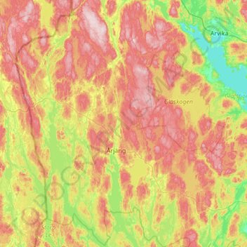
Name: Årjängs kommun topographic map, elevation, terrain.
Location: Årjängs kommun, Värmland County, Region Svealand, Sweden (59.17358 11.69113 59.72816 12.51233)
Average elevation: 577 ft
Minimum elevation: 141 ft
Maximum elevation: 1,115 ft
Other topographic maps
Click on a map to view its topography, its elevation and its terrain.
England
England, Arvika kommun, Värmland County, Region Svealand, Sweden
Average elevation: 945 ft
Hammarö kommun
Hammarö kommun, Värmland County, Region Svealand, Sweden
Average elevation: 148 ft
Kristinehamn
Sweden > Värmland County > Kristinehamn
Kristinehamn, Värmland County, Region Svealand, 681 30, Sweden
Average elevation: 256 ft
Östmark distrikt
Sweden > Värmland County > Östmark
Östmark distrikt, Östmark, Torsby, Värmland County, Region Svealand, Sweden
Average elevation: 486 ft