
Zahara topographic map
Interactive map
Click on the map to display elevation.
About this map
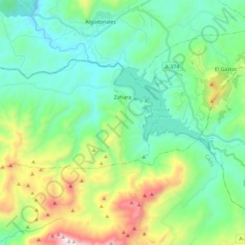
Name: Zahara topographic map, elevation, terrain.
Location: Zahara, Sierra de Cádiz, Cádiz, Andaluzia, 11688, Espanha (36.79478 -5.52320 36.86018 -5.36479)
Average elevation: 1,946 ft
Minimum elevation: 758 ft
Maximum elevation: 5,322 ft
Other topographic maps
Click on a map to view its topography, its elevation and its terrain.
Setenil de las Bodegas
Espanha > Andaluzia > Sierra de Cádiz
Setenil de las Bodegas, Sierra de Cádiz, Cádiz, Andaluzia, 11692, Espanha
Average elevation: 2,257 ft