
Kowloon topographic map
Interactive map
Click on the map to display elevation.
About this map
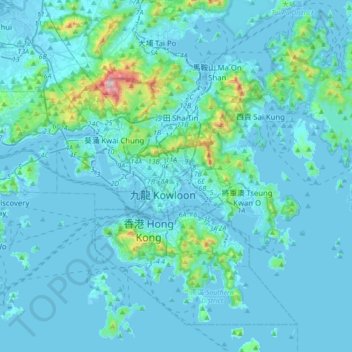
Name: Kowloon topographic map, elevation, terrain.
Location: Kowloon, Kowloon City District, Hong Kong, KIL 3348, PRC (22.16727 114.02987 22.48727 114.34987)
Average elevation: 226 ft
Minimum elevation: -30 ft
Maximum elevation: 3,110 ft
Other topographic maps
Click on a map to view its topography, its elevation and its terrain.
Kowloon Tsai Park
Kowloon Tsai Park, Kowloon Tong, Kowloon, Kowloon City District, Hong Kong, PRC
Average elevation: 112 ft
Hung Hom Bay
Hung Hom Bay, Kowloon, Kowloon City District, Hong Kong, 00000, PRC
Average elevation: 46 ft
Ko Shan Road Park
Ko Shan Road Park, To Kwa Wan, Kowloon, Kowloon City District, Hong Kong, PRC
Average elevation: 66 ft
Hoi Sham Park
Hoi Sham Park, To Kwa Wan, Kowloon, Kowloon City District, Hong Kong, PRC
Average elevation: 49 ft