
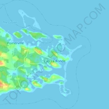
Cap La Ronde topographic map
Interactive map
Click on the map to display elevation.
About this map
Name: Cap La Ronde topographic map, elevation, terrain.
Average elevation: 7 ft
Minimum elevation: -16 ft
Maximum elevation: 115 ft
Other topographic maps
Click on a map to view its topography, its elevation and its terrain.
Battery Provincial Park
Canada > Nova Scotia > Municipality of the County of Richmond > St. Peter's
Battery Provincial Park, St. Peter's, Municipality of the County of Richmond, Richmond County, Nova Scotia, Canada
Average elevation: 30 ft
Louisdale
Canada > Nova Scotia > Municipality of the County of Richmond
Louisdale, Municipality of the County of Richmond, Richmond County, Nova Scotia, B0E 1V0, Canada
Average elevation: 85 ft
Potato Island
Canada > Nova Scotia > Municipality of the County of Richmond > Poirierville
Potato Island, Poirierville, Municipality of the County of Richmond, Richmond County, Nova Scotia, Canada
Average elevation: 13 ft
Thorn Creek
Canada > Nova Scotia > Municipality of the County of Richmond > Glasgow Point
Thorn Creek, Glasgow Point, Municipality of the County of Richmond, Richmond County, Nova Scotia, Canada
Average elevation: 13 ft
St. Peters Inlet
Canada > Nova Scotia > Municipality of the County of Richmond > Barra Head
St. Peters Inlet, Chapel Island 5, Barra Head, Municipality of the County of Richmond, Richmond County, Nova Scotia, Canada
Average elevation: 56 ft
Berry Island
Canada > Nova Scotia > Municipality of the County of Richmond > Martinique
Berry Island, Martinique, Municipality of the County of Richmond, Richmond County, Nova Scotia, B0E 1V0, Canada
Average elevation: 135 ft