
Waikoau topographic map
Interactive map
Click on the map to display elevation.
About this map
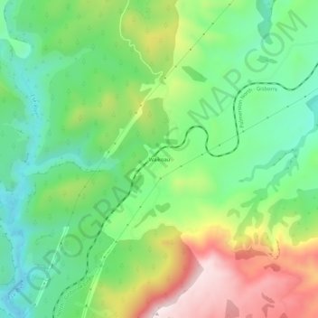
Name: Waikoau topographic map, elevation, terrain.
Location: Waikoau, Hastings District, Hawke's Bay, New Zealand (-39.25516 176.79684 -39.21516 176.83684)
Average elevation: 951 ft
Minimum elevation: 302 ft
Maximum elevation: 2,060 ft
Other topographic maps
Click on a map to view its topography, its elevation and its terrain.
Hastings
New Zealand > Hawke's Bay > Hastings District
Hastings, Hastings District, Hawke's Bay, 4122, New Zealand
Average elevation: 223 ft
Te Haroto
New Zealand > Hawke's Bay > Hastings District
Te Haroto, Hastings District, Hawke's Bay, New Zealand
Average elevation: 2,123 ft
Kereru
New Zealand > Hawke's Bay > Hastings District
Kereru, Hastings District, Hawke's Bay, New Zealand
Average elevation: 1,001 ft
Havelock North
New Zealand > Hawke's Bay > Hastings District
Havelock North, Hastings District, Hawke's Bay, 4130, New Zealand
Average elevation: 148 ft
Poukawa
New Zealand > Hawke's Bay > Hastings District
Poukawa, Hastings District, Hawke's Bay, New Zealand
Average elevation: 161 ft
Twyford
New Zealand > Hawke's Bay > Hastings District > Hastings
Twyford, Hastings, Hastings District, Hawke's Bay, 4154, New Zealand
Average elevation: 62 ft
Tutira
New Zealand > Hawke's Bay > Hastings District
Tutira, Hastings District, Hawke's Bay, New Zealand
Average elevation: 627 ft
Mangateretere
New Zealand > Hawke's Bay > Hastings District > Hastings
Mangateretere, Hastings, Hastings District, Hawke's Bay, 4172, New Zealand
Average elevation: 30 ft
Maraekakaho
New Zealand > Hawke's Bay > Hastings District > Maraekakaho
Maraekakaho, Hastings District, Hawke's Bay, New Zealand
Average elevation: 387 ft
Matangi
New Zealand > Hawke's Bay > Hastings District > Hastings
Matangi, Hastings, Hastings District, Hawke's Bay, 4295, New Zealand
Average elevation: 614 ft
Otatara Pā
New Zealand > Hawke's Bay > Hastings District > Napier > Waiohiki
Otatara Pā, Springfield Road, Waiohiki, Napier, Hastings District, Hawke's Bay, 4142, New Zealand
Average elevation: 102 ft
Sherenden
New Zealand > Hawke's Bay > Hastings District > Sherenden
Sherenden, Hastings District, Hawke's Bay, New Zealand
Average elevation: 846 ft
Lake Tutira
New Zealand > Hawke's Bay > Hastings District
Lake Tutira, Hastings District, Hawke's Bay, New Zealand
Average elevation: 646 ft
Crownthorpe
New Zealand > Hawke's Bay > Hastings District
Crownthorpe, Hastings District, Hawke's Bay, New Zealand
Average elevation: 551 ft
Maraetotara River
New Zealand > Hawke's Bay > Hastings District
Maraetotara River, Hastings District, Hawke's Bay, 4180, New Zealand
Average elevation: 344 ft