
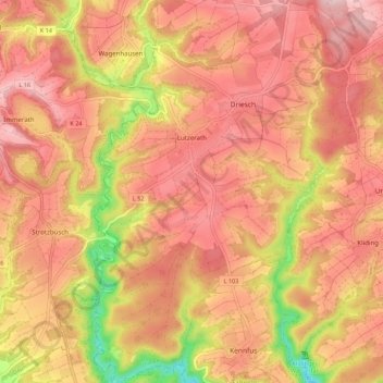
Lutzerath topographic map
Interactive map
Click on the map to display elevation.
About this map
Name: Lutzerath topographic map, elevation, terrain.
Average elevation: 1,260 ft
Minimum elevation: 696 ft
Maximum elevation: 1,558 ft
Other topographic maps
Click on a map to view its topography, its elevation and its terrain.
Faid
Allemagne > Rhénanie-Palatinat > Landkreis Cochem-Zell
Faid, Cochem, Landkreis Cochem-Zell, Rhénanie-Palatinat, Allemagne
Average elevation: 1,165 ft
Auderath
Allemagne > Rhénanie-Palatinat > Landkreis Cochem-Zell
Auderath, Ulmen, Landkreis Cochem-Zell, Rhénanie-Palatinat, Allemagne
Average elevation: 1,447 ft
Cochem
Allemagne > Rhénanie-Palatinat > Landkreis Cochem-Zell
Cochem, Landkreis Cochem-Zell, Rhénanie-Palatinat, Allemagne
Average elevation: 938 ft
Zell (Mosel)
Allemagne > Rhénanie-Palatinat > Landkreis Cochem-Zell
Zell (Mosel), Landkreis Cochem-Zell, Rhénanie-Palatinat, 56856, Allemagne
Average elevation: 942 ft