
Sierra de Guadarrama topographic map
Interactive map
Click on the map to display elevation.
About this map
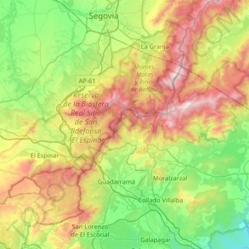
Name: Sierra de Guadarrama topographic map, elevation, terrain.
Average elevation: 4,072 ft
Minimum elevation: 2,100 ft
Maximum elevation: 7,943 ft
The range runs southwest–northeast, extending from the province of Ávila in the southwest, through the Community of Madrid, to the province of Segovia in the northeast. The range measures approximately 80 kilometres (50 mi) in length. Its highest peak is Peñalara, 2,428 metres (7,966 ft) in elevation.