
Villa Libertad Casica topographic map
Interactive map
Click on the map to display elevation.
About this map
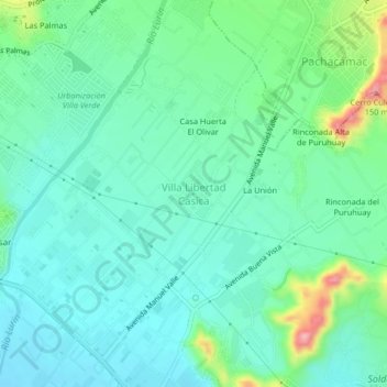
Name: Villa Libertad Casica topographic map, elevation, terrain.
Average elevation: 157 ft
Minimum elevation: 39 ft
Maximum elevation: 545 ft
Other topographic maps
Click on a map to view its topography, its elevation and its terrain.
Plaza de Armas de Lurín
Plaza de Armas de Lurín, Huerta Centinela, Lurín, Province of Lima, Lima Metropolitan Area, Lima, Peru
Average elevation: 56 ft
Complejo Santuario Arquelógico Pachacamac
Complejo Santuario Arquelógico Pachacamac, Lurín, Province of Lima, Lima Metropolitan Area, Lima, Peru
Average elevation: 75 ft
Pachacámac Monumental Archaeological Zone
Pachacámac Monumental Archaeological Zone, Lurín, Province of Lima, Lima Metropolitan Area, Lima, Peru
Average elevation: 164 ft