
Lachen topographic map
Interactive map
Click on the map to display elevation.
About this map
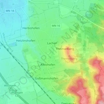
Name: Lachen topographic map, elevation, terrain.
Average elevation: 2,142 ft
Minimum elevation: 1,991 ft
Maximum elevation: 2,497 ft
Other topographic maps
Click on a map to view its topography, its elevation and its terrain.
Erisried
Deutschland > Bayern > Landkreis Unterallgäu
Erisried, Stetten, Dirlewang, Landkreis Unterallgäu, Bayern, 87778, Deutschland
Average elevation: 2,133 ft
Markt Rettenbach
Deutschland > Bayern > Landkreis Unterallgäu
Markt Rettenbach, Landkreis Unterallgäu, Bayern, 87733, Deutschland
Average elevation: 2,303 ft