
"La Litera" topographic map
Interactive map
Click on the map to display elevation.
About this map
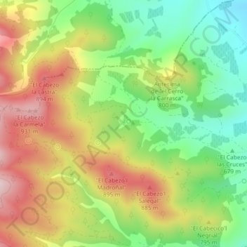
Name: "La Litera" topographic map, elevation, terrain.
Average elevation: 2,474 ft
Minimum elevation: 1,972 ft
Maximum elevation: 3,058 ft
Other topographic maps
Click on a map to view its topography, its elevation and its terrain.
Cabezo de la Cruz
España > Aragón > Campo de Cariñena > Cosuenda
Cabezo de la Cruz, Cosuenda, Campo de Cariñena, Zaragoza, Aragón, 50409, España
Average elevation: 2,638 ft