
Simon Bolivar topographic map
Interactive map
Click on the map to display elevation.
About this map
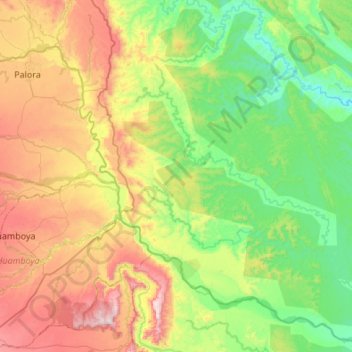
Name: Simon Bolivar topographic map, elevation, terrain.
Location: Simon Bolivar, Pastaza, Ecuador (-2.12528 -77.88701 -1.58347 -77.42680)
Average elevation: 2,274 ft
Minimum elevation: 1,119 ft
Maximum elevation: 4,642 ft
Other topographic maps
Click on a map to view its topography, its elevation and its terrain.
Veracruz (Indillama) (Cab. en Indillama)
Veracruz (Indillama) (Cab. en Indillama), Pastaza, Ecuador
Average elevation: 2,805 ft
Teniente Hugo Ortiz
Teniente Hugo Ortiz, Pastaza, Ecuador
Average elevation: 3,199 ft
Montalvo (Andoas)
Montalvo (Andoas), Pastaza, Ecuador
Average elevation: 1,040 ft