
Uhrwiller topographic map
Interactive map
Click on the map to display elevation.
About this map
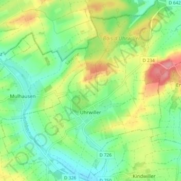
Name: Uhrwiller topographic map, elevation, terrain.
Average elevation: 696 ft
Minimum elevation: 568 ft
Maximum elevation: 906 ft
Other topographic maps
Click on a map to view its topography, its elevation and its terrain.
Griesheim-sur-Souffel
Griesheim-sur-Souffel, Saverne, Bas-Rhin, Grand Est, France métropolitaine, 67370, France
Average elevation: 538 ft
Wasselonne
Wasselonne, Molsheim, Bas-Rhin, Grand Est, France métropolitaine, 67310, France
Average elevation: 883 ft
Breitenbach
Breitenbach, Sélestat-Erstein, Bas-Rhin, Grand Est, France métropolitaine, 67220, France
Average elevation: 1,995 ft
Saint-Martin
France > Grand Est > Bas-Rhin > Saint-Martin
Saint-Martin, Sélestat-Erstein, Bas-Rhin, Grand Est, France métropolitaine, 67220, France
Average elevation: 1,168 ft
Saint-Maurice
Saint-Maurice, Sélestat-Erstein, Bas-Rhin, Grand Est, France métropolitaine, 67220, France
Average elevation: 955 ft
Saint-Pierre
Saint-Pierre, Sélestat-Erstein, Bas-Rhin, Grand Est, France métropolitaine, 67140, France
Average elevation: 604 ft
Griesheim-près-Molsheim
Griesheim-près-Molsheim, Molsheim, Bas-Rhin, Grand Est, France métropolitaine, 67870, France
Average elevation: 581 ft
Bischwiller
Bischwiller, Haguenau-Wissembourg, Bas-Rhin, Grand Est, France métropolitaine, 67240, France
Average elevation: 427 ft