
Winnipesaukee topographic map
Click on the map to display elevation.
About this map
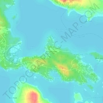
Name: Winnipesaukee topographic map, elevation, terrain.
Average elevation: 528 ft
Minimum elevation: 492 ft
Maximum elevation: 712 ft
Carroll County trails, hiking, mountain biking, running and outdoor activities
Other topographic maps
Click on a map to view its topography, its elevation and its terrain.
Black Cat Island
United States > New Hampshire > Carroll County > Moultonborough
Average elevation: 512 ft
Nineacre Island
United States > New Hampshire > Carroll County > Moultonborough
Average elevation: 518 ft
Castle in the Clouds
United States > New Hampshire > Carroll County > Moultonborough
Average elevation: 1,191 ft