
Thank you for supporting this site ❤️
Make a donation
Make a donation
Gear up for your next adventure:
As an Amazon Associate, this site earns from qualifying purchases at no extra cost to you.
Abeokuta topographic map
Click on the map to display elevation.
Thank you for supporting this site ❤️
Make a donation
Make a donation
Gear up for your next adventure:
As an Amazon Associate, this site earns from qualifying purchases at no extra cost to you.
About this map
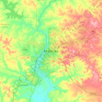
Name: Abeokuta topographic map, elevation, terrain.
Location: Abeokuta, Abeokuta South, Ogun State, 111101, Nigeria (6.99471 3.18673 7.31471 3.50673)
Average elevation: 312 ft
Minimum elevation: 39 ft
Maximum elevation: 719 ft
Thank you for supporting this site ❤️
Make a donation
Make a donation
Gear up for your next adventure:
As an Amazon Associate, this site earns from qualifying purchases at no extra cost to you.