
Make a donation
Gear up for your next adventure:
As an Amazon Associate, this site earns from qualifying purchases at no extra cost to you.
Tocoa topographic map
Click on the map to display elevation.
Make a donation
Gear up for your next adventure:
As an Amazon Associate, this site earns from qualifying purchases at no extra cost to you.
Tocoa
Tocoa, Colón is a city, with a population of 63,320 (2023 calculation), and a municipality in the northern Honduran department of Colón slightly inland at 38 m elevation in the valley of Aguán on the right bank of the river.
Make a donation
Gear up for your next adventure:
As an Amazon Associate, this site earns from qualifying purchases at no extra cost to you.
About this map
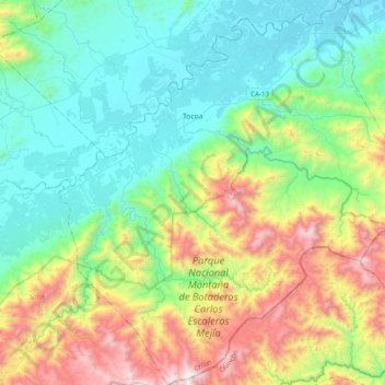
Name: Tocoa topographic map, elevation, terrain.
Location: Tocoa, Colón, 32301, Honduras (15.39387 -86.14154 15.77072 -85.78530)
Average elevation: 1,562 ft
Minimum elevation: 30 ft
Maximum elevation: 5,410 ft
Make a donation
Gear up for your next adventure:
As an Amazon Associate, this site earns from qualifying purchases at no extra cost to you.
Other topographic maps
Click on a map to view its topography, its elevation and its terrain.