
Stauden topographic map
Interactive map
Click on the map to display elevation.
About this map
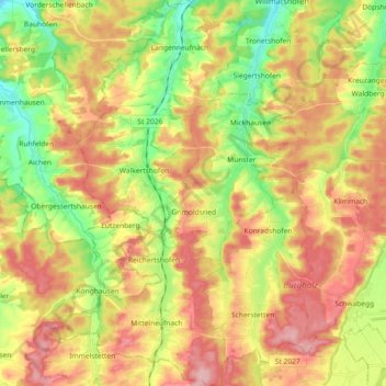
Name: Stauden topographic map, elevation, terrain.
Location: Stauden, Landkreis Augsburg, Beieren, Duitsland (48.15776 10.54204 48.27942 10.67116)
Average elevation: 1,857 ft
Minimum elevation: 1,617 ft
Maximum elevation: 2,093 ft
Other topographic maps
Click on a map to view its topography, its elevation and its terrain.
Welden
Duitsland > Beieren > Landkreis Augsburg
Welden, Landkreis Augsburg, Beieren, 86465, Duitsland
Average elevation: 1,631 ft
Westendorf
Duitsland > Beieren > Landkreis Augsburg
Westendorf, Nordendorf, Landkreis Augsburg, Beieren, 86707, Duitsland
Average elevation: 1,421 ft