Geolocate

Marblemount topographic map

Click on the map to display elevation.

About this map

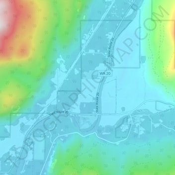
Name: Marblemount topographic map, elevation, terrain.

Location: Marblemount, Skagit County, Washington, United States (48.50784 -121.47189 48.56210 -121.41194)

Average elevation: 817 ft

Minimum elevation: 282 ft

Maximum elevation: 3,675 ft

Skagit County trails, hiking, mountain biking, running and outdoor activities

Gear up for your next adventure:

🦶Hiking Gaiters - Keep debris and water out of your boots
Backpacking Tent - Lightweight and durable tent for multi‑day hikes
👟Men's Trail Runners - Lightweight footwear for fast-paced exploration and light hiking
🧭Outdoor Navigation Book - Learn advanced navigation skills
📱Solar Portable Charger - Solar power bank for charging devices off‑grid

As an Amazon Associate, this site earns from qualifying purchases at no extra cost to you.