
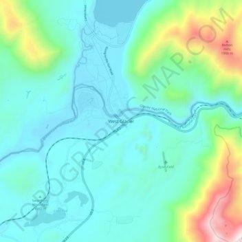
West Glacier topographic map
Interactive map
Click on the map to display elevation.
About this map
Name: West Glacier topographic map, elevation, terrain.
Average elevation: 3,940 ft
Minimum elevation: 3,117 ft
Maximum elevation: 7,257 ft
The community, heavily dependent on tourism, has a small permanent population that expands significantly during the summer tourist season; most area businesses are likewise seasonal—including the 18-hole golf course—and are primarily geared towards travelers. The elevation is 3,169 feet (966 m).
Other topographic maps
Click on a map to view its topography, its elevation and its terrain.
Glacier National Park
United States > Montana > Flathead County
Glacier National Park, Flathead County, Montana, United States
Average elevation: 5,230 ft
Whitefish
United States > Montana > Flathead County
Whitefish, Flathead County, Montana, United States
Average elevation: 3,520 ft
Logan Pass
United States > Montana > Flathead County
Logan Pass, Flathead County, Montana, United States
Average elevation: 6,693 ft
Kalispell
United States > Montana > Flathead County
Kalispell, Flathead County, Montana, United States
Average elevation: 3,064 ft
Marion
United States > Montana > Flathead County
Marion, Flathead County, Montana, United States
Average elevation: 4,055 ft
Niarada
United States > Montana > Flathead County
Niarada, Flathead County, Montana, United States
Average elevation: 3,455 ft
Evergreen
United States > Montana > Flathead County
Evergreen, Flathead County, Montana, United States
Average elevation: 2,936 ft
Columbia Falls
United States > Montana > Flathead County
Columbia Falls, Flathead County, Montana, 59912, United States
Average elevation: 3,064 ft
Condor Peak
United States > Montana > Flathead County
Condor Peak, Flathead County, Montana, United States
Average elevation: 6,063 ft
Apgar
United States > Montana > Flathead County
Apgar, Flathead County, Montana, 59936, United States
Average elevation: 3,543 ft
Somers
United States > Montana > Flathead County
Somers, Flathead County, Montana, United States
Average elevation: 3,002 ft
Lakeside
United States > Montana > Flathead County
Lakeside, Flathead County, Montana, 59922, United States
Average elevation: 3,392 ft
Bigfork
United States > Montana > Flathead County
Bigfork, Flathead County, Montana, United States
Average elevation: 3,025 ft
Bowman Lake
United States > Montana > Flathead County
Bowman Lake, Flathead County, Montana, United States
Average elevation: 5,377 ft
Polebridge
United States > Montana > Flathead County
Polebridge, Flathead County, Montana, 59928, United States
Average elevation: 3,668 ft
Kalispell
United States > Montana > Flathead County > Kalispell
Kalispell, Flathead County, Montana, 59901-4451, United States
Average elevation: 3,461 ft
Canyon Point
United States > Montana > Flathead County
Canyon Point, Flathead County, Montana, United States
Average elevation: 5,741 ft
Graves Creek
United States > Montana > Flathead County
Graves Creek, Flathead County, Montana, United States
Average elevation: 5,558 ft
Lake McDonald
United States > Montana > Flathead County
Lake McDonald, Flathead County, Montana, United States
Average elevation: 3,967 ft
Kila
United States > Montana > Flathead County
Kila, Flathead County, Montana, 59920, United States
Average elevation: 3,323 ft
Lake Ellen Wilson
United States > Montana > Flathead County
Lake Ellen Wilson, Flathead County, Montana, United States
Average elevation: 6,890 ft
Coal Creek
United States > Montana > Flathead County
Coal Creek, Flathead County, Montana, United States
Average elevation: 4,222 ft
Cone Peak
United States > Montana > Flathead County
Cone Peak, Flathead County, Montana, United States
Average elevation: 5,968 ft
Heavens Peak
United States > Montana > Flathead County
Heavens Peak, Flathead County, Montana, United States
Average elevation: 6,742 ft