
Marion topographic map
Click on the map to display elevation.
About this map
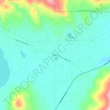
Name: Marion topographic map, elevation, terrain.
Location: Marion, Flathead County, Montana, United States (48.08561 -114.68339 48.12561 -114.64339)
Average elevation: 4,055 ft
Minimum elevation: 3,832 ft
Maximum elevation: 4,797 ft
Flathead County trails, hiking, mountain biking, running and outdoor activities
Other topographic maps
Click on a map to view its topography, its elevation and its terrain.
Kalispell
United States > Montana > Flathead County
Kalispell is located at 48°11′52″N 114°18′58″W / 48.19778°N 114.31611°W / 48.19778; -114.31611 (48.197801, −114.316068), at an elevation of 2,956 feet (901 m).
Average elevation: 3,064 ft
Kalispell
United States > Montana > Flathead County
Kalispell is located at 48°11′52″N 114°18′58″W / 48.19778°N 114.31611°W / 48.19778; -114.31611 (48.197801, −114.316068), at an elevation of 2,956 feet (901 m).
Average elevation: 3,064 ft
Lake McDonald
United States > Montana > Flathead County
Lake McDonald is the largest lake in Glacier National Park. It is located at 48°35′N 113°55′W / 48.583°N 113.917°W / 48.583; -113.917 in Flathead County in the U.S. state of Montana. Lake McDonald is approximately 10 miles (16 km) long, and over a mile (1.6 km) wide and 472 feet (130 m) deep,…
Average elevation: 3,967 ft
Vulture Glacier
United States > Montana > Flathead County
Vulture Glacier is in Glacier National Park, U.S. state of Montana. The glacier is situated just south of Vulture Peak at an average elevation of 8,412 feet (2,564 m) above sea level. Between 1966 and 2005, Vulture Glacier lost over 50 percent of its surface area.
Average elevation: 7,848 ft
Kalispell
United States > Montana > Flathead County
Kalispell is located at 48°11′52″N 114°18′58″W / 48.19778°N 114.31611°W / 48.19778; -114.31611 (48.197801, −114.316068), at an elevation of 2,956 feet (901 m).
Average elevation: 3,064 ft