
Evinos topographic map
Interactive map
Click on the map to display elevation.
About this map
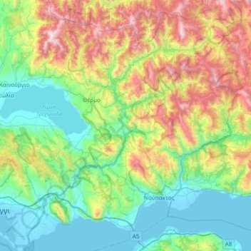
Name: Evinos topographic map, elevation, terrain.
Average elevation: 1,768 ft
Minimum elevation: -13 ft
Maximum elevation: 6,266 ft
Other topographic maps
Click on a map to view its topography, its elevation and its terrain.
Megali Mandinia
Griechenland > Peloponnes, Westgriechenland und Ionische Inseln > Regionalbezirk Messenien > Δημοτική Ενότητα Αβίας > Ακρογιάλι
Megali Mandinia, Ίριδος, Ακρογιάλι, Δημοτική Ενότητα Αβίας, Δήμος Δυτικής Μάνης, Regionalbezirk Messenien, Region Peloponnes, Peloponnes, Westgriechenland und Ionische Inseln, 241 00, Griechenland
Average elevation: 430 ft
Kiliomenos
Griechenland > Peloponnes, Westgriechenland und Ionische Inseln > Regionalbezirk Zakynthos > Δημοτική Ενότητα Αρτεμισίων
Kiliomenos, Δημοτική Ενότητα Αρτεμισίων, Δήμος Ζακύνθου, Regionalbezirk Zakynthos, Region der Ionischen Inseln, Peloponnes, Westgriechenland und Ionische Inseln, 290 92, Griechenland
Average elevation: 1,414 ft
Ζάκυνθος
Griechenland > Peloponnes, Westgriechenland und Ionische Inseln > Regionalbezirk Zakynthos
Ζάκυνθος, Regionalbezirk Zakynthos, Region der Ionischen Inseln, Peloponnes, Westgriechenland und Ionische Inseln, Griechenland
Average elevation: 269 ft
Κεφαλονιά
Griechenland > Peloponnes, Westgriechenland und Ionische Inseln > Regionalbezirk Kefalonia
Κεφαλονιά, Regionalbezirk Kefalonia, Region der Ionischen Inseln, Peloponnes, Westgriechenland und Ionische Inseln, Griechenland
Average elevation: 453 ft
Peloponnes
Griechenland > Peloponnes, Westgriechenland und Ionische Inseln > Πάπαρης
Peloponnes, Κάτω Ασέα - Πάπαρης, κ. Πάπαρη, Πάπαρης, Δήμος Τρίπολης, Regionalbezirk Arkadien, Region Peloponnes, Peloponnes, Westgriechenland und Ionische Inseln, 22027, Griechenland
Average elevation: 843 ft
Ladonas
Griechenland > Peloponnes, Westgriechenland und Ionische Inseln
Ladonas, Δήμος Γορτυνίας, Regionalbezirk Arkadien, Region Peloponnes, Peloponnes, Westgriechenland und Ionische Inseln, Griechenland
Average elevation: 2,014 ft
Kastraki-Stausee
Griechenland > Peloponnes, Westgriechenland und Ionische Inseln > Νέο Γιαννόπουλο
Kastraki-Stausee, Στράτος - Πατιόπουλο, Κοινότητα Μπαμπαλιού, Νέο Γιαννόπουλο, Δήμος Αμφιλοχίας, Regionalbezirk Ätolien-Akarnanien, Region Westgriechenland, Peloponnes, Westgriechenland und Ionische Inseln, 30018, Griechenland
Average elevation: 1,014 ft
Peloponnes, Westgriechenland und Ionische Inseln
Griechenland > Peloponnes, Westgriechenland und Ionische Inseln
Peloponnes, Westgriechenland und Ionische Inseln, Griechenland
Average elevation: 705 ft
Mornos
Griechenland > Peloponnes, Westgriechenland und Ionische Inseln
Mornos, Δήμος Δωρίδος, Regionalbezirk Fokida, Region Westgriechenland, Peloponnes, Westgriechenland und Ionische Inseln, 33060, Griechenland
Average elevation: 1,516 ft
Kremasta-Stausee
Griechenland > Peloponnes, Westgriechenland und Ionische Inseln > Τρίκλινο
Kremasta-Stausee, Γέφυρα Βέργας - Δυτική Φραγκίστα, Κοινότητα Τρίκλινου, Τρίκλινο, Δήμος Αμφιλοχίας, Regionalbezirk Ätolien-Akarnanien, Region Westgriechenland, Peloponnes, Westgriechenland und Ionische Inseln, 30017, Griechenland
Average elevation: 1,703 ft