
Los Katíos National Park topographic map
Interactive map
Click on the map to display elevation.
About this map
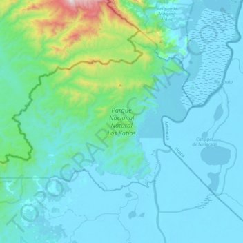
Name: Los Katíos National Park topographic map, elevation, terrain.
Location: Los Katíos National Park, Urabá, Chocó, RAP Pacífico, Colombia (7.67867 -77.39808 7.96955 -77.00584)
Average elevation: 479 ft
Minimum elevation: -7 ft
Maximum elevation: 4,442 ft
Los Katíos National Natural Park (Spanish: Parque Nacional Natural (PNN) Los Katíos) is a protected area located in northwest Colombia which covers about 720 km2 (280 sq mi). The elevation ranges between 50 and 600 m (160 and 1,970 ft). It is a part of the Darién Gap, a densely forested area shared by Panama and Colombia, and is contiguous with the Darién National Park in Panama. The Pan-American Highway, when completed as proposed, would pass near or through Los Katíos. The park was declared a UNESCO World Heritage Site in 1994 due to the extraordinary diversity of plant and animal species represented.
Other topographic maps
Click on a map to view its topography, its elevation and its terrain.
Pizarro
Colombia > Chocó > Bajo Baudó (Pizarro)
Pizarro, Bajo Baudó (Pizarro), Pacífico Sur, Chocó, Colombia
Average elevation: 49 ft
Bahía Solano (Mutis)
Bahía Solano (Mutis), Pacífico Norte, Chocó, RAP Pacífico, Colombia
Average elevation: 427 ft
Docordó
Colombia > Chocó > El Litoral del San Juan
Docordó, El Litoral del San Juan, Pacífico Sur, Chocó, Colombia
Average elevation: 23 ft
Huaca
Colombia > Chocó > Bahía Solano (Mutis)
Huaca, Bahía Solano (Mutis), Pacífico Norte, Chocó, Colombia
Average elevation: 154 ft