
Make a donation
Gear up for your next adventure:
As an Amazon Associate, this site earns from qualifying purchases at no extra cost to you.
Gash-Barka topographic map
Click on the map to display elevation.
Make a donation
Gear up for your next adventure:
As an Amazon Associate, this site earns from qualifying purchases at no extra cost to you.
Gash-Barka
It is situated in the south-west of the country, bordering the Anseba region to the north, and the Maekel (Central) and Debub (Southern) regions to the east; the country of Sudan lies to the west and Ethiopia to the south. The major crops in the region are bananas, tomatoes, cotton, onions, millet, sesame, green pepper and sweet melon. Within the entire country there existed extensive forestation as recently as 1900 AD; however, there is less than one percent forested area present in the country, and this deforestation trend has been mirrored in the region. Most of Eritrea was previously habitat for the endangered painted hunting dog, Lycaon pictus; however, this canid is now deemed extirpated from Gash-Barka and all of Eritrea due to the expanding human population in this country. The topography of the region has highland plateau, which are cooler than the regions around the coastal plains. There are two rainy seasons, the heavier one during summer and the lighter one during spring. The climate and geography of the region along with other regions of Eritrea is similar to the one of Ethiopia. The average elevation in the region is around 1,800 m (5,900 ft) to 2,100 m (6,900 ft). The hottest month is May recording temperatures up to 30 °C (86 °F), while the coldest month is December to February when it reaches freezing temperature. The region received around 508 mm (20.0 in) of rainfall and the soil is conducive for agriculture.
Make a donation
Gear up for your next adventure:
As an Amazon Associate, this site earns from qualifying purchases at no extra cost to you.
About this map
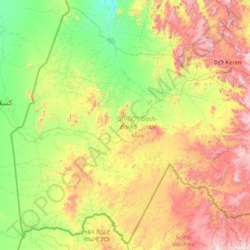
Name: Gash-Barka topographic map, elevation, terrain.
Location: Gash-Barka, Eritrea (14.18095 36.43337 16.29863 38.76234)
Average elevation: 2,999 ft
Minimum elevation: 1,165 ft
Maximum elevation: 8,041 ft
Make a donation
Gear up for your next adventure:
As an Amazon Associate, this site earns from qualifying purchases at no extra cost to you.
Other topographic maps
Click on a map to view its topography, its elevation and its terrain.
Make a donation
Gear up for your next adventure:
As an Amazon Associate, this site earns from qualifying purchases at no extra cost to you.
Make a donation
Gear up for your next adventure:
As an Amazon Associate, this site earns from qualifying purchases at no extra cost to you.
Make a donation
Gear up for your next adventure:
As an Amazon Associate, this site earns from qualifying purchases at no extra cost to you.