Geolocate

sa Pobla topographic map

Click on the map to display elevation.

About this map

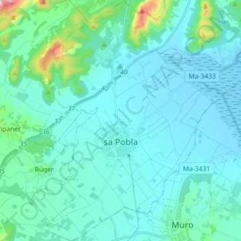
Name: sa Pobla topographic map, elevation, terrain.

Location: sa Pobla, Raiguer, Balearic Islands, 07420, Spain (39.73061 2.98513 39.82580 3.09244)

Average elevation: 171 ft

Minimum elevation: -10 ft

Maximum elevation: 1,453 ft

Gear up for your next adventure:

🔦Compact Flashlight - Reliable flashlight for emergencies
🧥Waterproof Jacket for Hiking - Breathable and rugged rain jacket for outdoor excursions
🩹Survival Bandages - High‑quality bandages for emergencies
🔭Telescopic Hiking Pole - Adjustable pole for hiking stability
📱Heavy-Duty Phone Cases - Drop-proof and waterproof protection for outdoor navigation

As an Amazon Associate, this site earns from qualifying purchases at no extra cost to you.