
Kaletepe Mahallesi topographic map
Interactive map
Click on the map to display elevation.
About this map
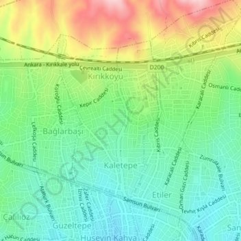
Name: Kaletepe Mahallesi topographic map, elevation, terrain.
Location: Kaletepe Mahallesi, Kırıkkale, Central Anatolia Region, Turkey (39.84841 33.50201 39.86639 33.51473)
Average elevation: 2,612 ft
Minimum elevation: 2,365 ft
Maximum elevation: 3,064 ft
Other topographic maps
Click on a map to view its topography, its elevation and its terrain.
Etiler Mahallesi
Etiler Mahallesi, Kırıkkale, Central Anatolia Region, Turkey
Average elevation: 2,635 ft
Tepebaşı Mahallesi
Tepebaşı Mahallesi, Kırıkkale, Central Anatolia Region, Turkey
Average elevation: 2,431 ft