
Paramankeni topographic map
Interactive map
Click on the map to display elevation.
About this map
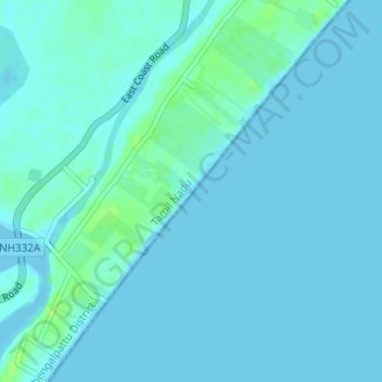
Name: Paramankeni topographic map, elevation, terrain.
Location: Paramankeni, Cheyyur, Chengalpattu District, Tamil Nadu, India (12.34308 80.06335 12.37300 80.08725)
Average elevation: 7 ft
Minimum elevation: -3 ft
Maximum elevation: 36 ft
Other topographic maps
Click on a map to view its topography, its elevation and its terrain.
Kadappakkam light house
India > Tamil Nadu > Cheyyur > Kadapakkam
Kadappakkam light house, Kadapakkam Road, Kadapakkam, Cheyyur, Chengalpattu District, Tamil Nadu, 603304, India
Average elevation: 16 ft
Kadapakkam
India > Tamil Nadu > Cheyyur
Kadapakkam, Cheyyur, Chengalpattu District, Tamil Nadu, 603304, India
Average elevation: 33 ft
Cheyur
India > Tamil Nadu > Cheyyur
Cheyur, Cheyyur, Chengalpattu District, Tamil Nadu, 603302, India
Average elevation: 26 ft