
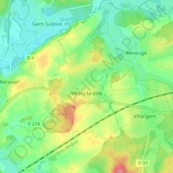
Villers-la-Ville topographic map
Interactive map
Click on the map to display elevation.
About this map
Name: Villers-la-Ville topographic map, elevation, terrain.
Average elevation: 938 ft
Minimum elevation: 846 ft
Maximum elevation: 1,096 ft
Other topographic maps
Click on a map to view its topography, its elevation and its terrain.
Plancher-Bas
France > Bourgogne-Franche-Comté > Haute-Saône
Plancher-Bas, Lure, Haute-Saône, Bourgogne-Franche-Comté, France métropolitaine, 70290, France
Average elevation: 1,722 ft
La Bruyère
France > Bourgogne-Franche-Comté > Haute-Saône
La Bruyère, Lure, Haute-Saône, Bourgogne-Franche-Comté, France métropolitaine, 70280, France
Average elevation: 1,253 ft
Fougerolles
France > Bourgogne-Franche-Comté > Haute-Saône > Fougerolles-Saint-Valbert
Fougerolles, Fougerolles-Saint-Valbert, Lure, Haute-Saône, Bourgogne-Franche-Comté, France métropolitaine, 70220, France
Average elevation: 1,309 ft
Mélisey
France > Bourgogne-Franche-Comté > Haute-Saône
Mélisey, Lure, Haute-Saône, Bourgogne-Franche-Comté, France métropolitaine, 70270, France
Average elevation: 1,316 ft