
Bhakhand topographic map
Interactive map
Click on the map to display elevation.
About this map
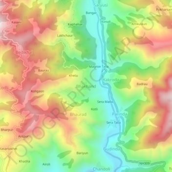
Name: Bhakhand topographic map, elevation, terrain.
Average elevation: 4,997 ft
Minimum elevation: 3,812 ft
Maximum elevation: 6,276 ft
Other topographic maps
Click on a map to view its topography, its elevation and its terrain.
Dungri Malli
India > Uttarakhand > Thailisain
Dungri Malli, Thailisain, Pauri Garhwal District, Uttarakhand, India
Average elevation: 6,693 ft
Thailisain
India > Uttarakhand > Thailisain
Thailisain, Pauri Garhwal, Uttarakhand, India
Average elevation: 5,591 ft
Chopta
India > Uttarakhand > Thailisain
Chopta, Thailisain, Pauri Garhwal District, Uttarakhand, 246275, India
Average elevation: 6,302 ft