
Make a donation
Gear up for your next adventure:
As an Amazon Associate, this site earns from qualifying purchases at no extra cost to you.
Gays Mills topographic map
Click on the map to display elevation.
Make a donation
Gear up for your next adventure:
As an Amazon Associate, this site earns from qualifying purchases at no extra cost to you.
About this map
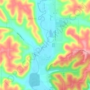
Name: Gays Mills topographic map, elevation, terrain.
Location: Gays Mills, Crawford County, Wisconsin, United States (43.30320 -90.87269 43.34501 -90.82326)
Average elevation: 892 ft
Minimum elevation: 679 ft
Maximum elevation: 1,178 ft
Crawford County trails, hiking, mountain biking, running and outdoor activities
Make a donation
Gear up for your next adventure:
As an Amazon Associate, this site earns from qualifying purchases at no extra cost to you.
Other topographic maps
Click on a map to view its topography, its elevation and its terrain.
North Clayton
United States > Wisconsin > Crawford County > Town of Clayton
Average elevation: 1,093 ft