
Villingen topographic map
Interactive map
Click on the map to display elevation.
About this map
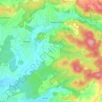
Name: Villingen topographic map, elevation, terrain.
Location: Villingen, Hungen, Landkreis Gießen, Hessen, Duitsland (50.48301 8.90414 50.51712 9.00216)
Average elevation: 633 ft
Minimum elevation: 453 ft
Maximum elevation: 974 ft
Other topographic maps
Click on a map to view its topography, its elevation and its terrain.
Gießen
Duitsland > Hessen > Landkreis Gießen
Gießen, Landkreis Gießen, Hessen, Duitsland
Average elevation: 669 ft
Hungen
Duitsland > Hessen > Landkreis Gießen
Hungen, Landkreis Gießen, Hessen, 35410, Duitsland
Average elevation: 525 ft
Heuchelheim
Duitsland > Hessen > Landkreis Gießen
Heuchelheim, Landkreis Gießen, Hessen, 35452, Duitsland
Average elevation: 574 ft