
Make a donation
Gear up for your next adventure:
As an Amazon Associate, this site earns from qualifying purchases at no extra cost to you.
Châtillon topographic map
Click on the map to display elevation.
Make a donation
Gear up for your next adventure:
As an Amazon Associate, this site earns from qualifying purchases at no extra cost to you.
About this map
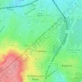
Name: Châtillon topographic map, elevation, terrain.
Average elevation: 335 ft
Minimum elevation: 210 ft
Maximum elevation: 558 ft
Make a donation
Gear up for your next adventure:
As an Amazon Associate, this site earns from qualifying purchases at no extra cost to you.
Other topographic maps
Click on a map to view its topography, its elevation and its terrain.
Jardin de la Mairie
France > Ile-de-France > Hauts-de-Seine > Boulogne-Billancourt
Average elevation: 171 ft
Make a donation
Gear up for your next adventure:
As an Amazon Associate, this site earns from qualifying purchases at no extra cost to you.
Hameau de Bois Preau
France > Ile-de-France > Hauts-de-Seine > Rueil-Malmaison
Average elevation: 295 ft