
Make a donation
Gear up for your next adventure:
As an Amazon Associate, this site earns from qualifying purchases at no extra cost to you.
EMD l'Estartit topographic map
Click on the map to display elevation.
Make a donation
Gear up for your next adventure:
As an Amazon Associate, this site earns from qualifying purchases at no extra cost to you.
EMD l'Estartit
L'Estartit stretches North-South from Cala Montgó, at the southern tip of the Bay of Roses (Badía de Roses) to the Ter River estuary in the Bay of Pals (Badía de Pals). East-West it extends three kilometers inland from the shoreline and includes the hills of Rocamaura and Torre Moratxa, and to the north of these the old farmhouse of Torre Ponça. The Montgrí Massif (Massís del Montgrí) plunges into the sea forming about 9 kilometers of high, rocky, and cut coast, in which we find several coves, including Cala Calella, Golfet del Falaguer, Cala Pedrosa and Cala Ferriola, as well as different caves, including the tunnel Roca Foradada and the Tres Coves, closest to Cala Montgó. The Medes Islands are an elevation within the sea of the Montgrí Massif range. From the GI-645 road, you can also see the lower peaks called Tossal Gros, Tossal Mitjà, Tossal Petit, and Puig de la Reina.
Make a donation
Gear up for your next adventure:
As an Amazon Associate, this site earns from qualifying purchases at no extra cost to you.
About this map
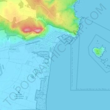
Name: EMD l'Estartit topographic map, elevation, terrain.
Average elevation: 82 ft
Minimum elevation: -16 ft
Maximum elevation: 653 ft
Make a donation
Gear up for your next adventure:
As an Amazon Associate, this site earns from qualifying purchases at no extra cost to you.