
Periférica topographic map
Interactive map
Click on the map to display elevation.
About this map
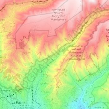
Name: Periférica topographic map, elevation, terrain.
Location: Periférica, La Paz, Pedro Domingo Murillo, La Paz, Bolivia (-16.49663 -68.15304 -16.42464 -68.07015)
Average elevation: 13,301 ft
Minimum elevation: 11,355 ft
Maximum elevation: 15,007 ft
Other topographic maps
Click on a map to view its topography, its elevation and its terrain.
Sur
Bolivia > La Paz > Pedro Domingo Murillo > La Paz
Sur, La Paz, Pedro Domingo Murillo, La Paz, Bolivia
Average elevation: 11,985 ft