
Sahel Chamali الساحل الشمالي topographic map
Interactive map
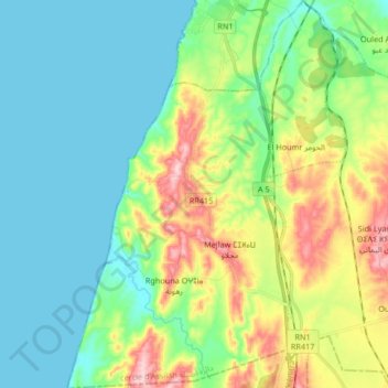
Click on the map to display elevation.
About this map
Name: Sahel Chamali الساحل الشمالي topographic map, elevation, terrain.
Average elevation: 207 ft
Minimum elevation: -3 ft
Maximum elevation: 722 ft
Other topographic maps
Click on a map to view its topography, its elevation and its terrain.
caïdat de Gharbia قيادة غربية
Morocco > cercle d'Assilah دائرة أصيلة
caïdat de Gharbia قيادة غربية, cercle d'Assilah دائرة أصيلة, Prefecture of Tangier - Assilah, Tangier-Tetouan-Al Hoceima, 90302, Morocco
Average elevation: 154 ft
Aquouass Briech أقواس برييش
Morocco > cercle d'Assilah دائرة أصيلة > Aquouass Briech أقواس برييش
Aquouass Briech أقواس برييش, caïdat de Gharbia قيادة غربية, cercle d'Assilah دائرة أصيلة, Prefecture of Tangier - Assilah, Tangier-Tetouan-Al Hoceima, Morocco
Average elevation: 72 ft