Geolocate

Guaymas topographic map

Click on the map to display elevation.

About this map

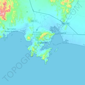
Name: Guaymas topographic map, elevation, terrain.

Location: Guaymas, Sonora, 85400, Mexico (27.76164 -111.05941 28.08164 -110.73941)

Average elevation: 121 ft

Minimum elevation: -10 ft

Maximum elevation: 2,526 ft

Gear up for your next adventure:

🎒Day Hiking Backpack - Lightweight backpack perfect for day trips and outdoor adventures
🛶Inflatable Kayak - Portable kayak for rivers, lakes, and expeditions
📌Outdoor GPS Map App - Apps and devices for digital topographic navigation
🔥Plasma Lighters - Windproof lighters that work in any weather condition
🧴Hand Sanitizer - Keep hands clean while hiking

As an Amazon Associate, this site earns from qualifying purchases at no extra cost to you.