
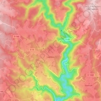
Lapleau topographic map
Interactive map
Click on the map to display elevation.
About this map
Name: Lapleau topographic map, elevation, terrain.
Average elevation: 1,644 ft
Minimum elevation: 965 ft
Maximum elevation: 1,991 ft
Other topographic maps
Click on a map to view its topography, its elevation and its terrain.
Troche
France > Nouvelle-Aquitaine > Corrèze
Troche, Brive-la-Gaillarde, Corrèze, Nouvelle-Aquitaine, France métropolitaine, 19230, France
Average elevation: 1,224 ft
Lintillac
France > Nouvelle-Aquitaine > Corrèze > Ussac
Lintillac, Ussac, Brive-la-Gaillarde, Corrèze, Nouvelle-Aquitaine, France métropolitaine, 19270, France
Average elevation: 397 ft
Aubazines
France > Nouvelle-Aquitaine > Corrèze
Aubazines, Brive-la-Gaillarde, Corrèze, Nouvelle-Aquitaine, France métropolitaine, 19190, France
Average elevation: 1,165 ft
Lafage-sur-Sombre
France > Nouvelle-Aquitaine > Corrèze
Lafage-sur-Sombre, Ussel, Corrèze, Nouvelle-Aquitaine, France métropolitaine, 19320, France
Average elevation: 1,942 ft
Albignac
France > Nouvelle-Aquitaine > Corrèze > Albignac
Albignac, Brive-la-Gaillarde, Corrèze, Nouvelle-Aquitaine, France métropolitaine, 19190, France
Average elevation: 1,056 ft
Uzerche
France > Nouvelle-Aquitaine > Corrèze > Uzerche
Uzerche, Tulle, Corrèze, Nouvelle-Aquitaine, France métropolitaine, 19140, France
Average elevation: 1,217 ft
Brive-la-Gaillarde
France > Nouvelle-Aquitaine > Corrèze
Brive-la-Gaillarde, Corrèze, Nouvelle-Aquitaine, France métropolitaine, 19100, France
Average elevation: 584 ft